
JKartta
11.12.2014 - v 0.8.0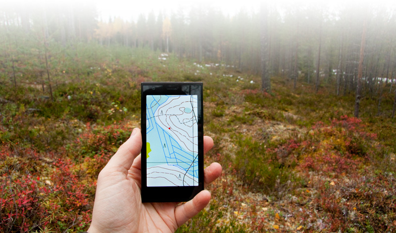
JKartta is map browser for Finnish National Land Survey topological maps and OpenStreetMap. For OpenStreetMap MapQuest default map tiles (globally) are available, and with NLS maps topological and aerial maps, both with boundaries and identifications are available. Naturally app also has GPS location and route tracking available, as well as import and export of .gpx waypoints (as "Points of Interest") and routes.
You can also import your custom overlays (information on top of normal map) or
map sheets to program as somewhat simplified MapInfo .tab format.
You can download example on using overlays from here.
This example is based on open data of NLS (© Maanmittauslaitos and cities) and
has been modified to be usable on the phone.
The overlay data used should be kept relatively small, max 2400x2400 pixels per tile,
especially if you want to load multiple tiles at same time. The example above has been
scaled down to 4800x4800 pixels which is still manageable if multiple tiles are not
used at same time. It will still take a lot of limited phone memory, however.
OpenStreetMap (tiles courtesy of MapQuest) is always available. If you wish to
use Finnish NLS tile sets (note, only areas within Finnish borders are available!),
you must purchase them from us (the data used by program is not free to us, either).
Contact us for details.
The app is now available from Jolla Store, you can download it from there.
A word on use
Location fix
If you're stuck with initial "waiting gps fix" message, first verify that you actually have location enabled in phone settings. At the moment JKartta doesn't detect if this setting is disabled and thus will be stuck waiting for GPS fix that it will never get.You will need to close and restart JKartta after enabling this option before it takes effect. When GPS is enabled and waiting for fix, you should see small flashing satellite picture (or solid bright when lock is acquired) next to battery charge indication at phone's status view.
If this does not help, try moving to a place where there is clear visibility to sky. JKartta does not use AGPS (network-assisted GPS) and relies only on signal received from actual GPS satellites. This means that when satellite signal is bad - like so often indoors - phone cannot get GPS fix (and satellite icon mentioned above will keep flashing indefinitely)
Route tracking
At the moment measured route is always continuous - from start to finish, and even when distance traveled between pausing and resuming is included in measurement. Continuing previous measurement (ie, continuing hike after night) isn't possible either.I have some ideas on how to implement both of these, but question is whether you, the user, need these features.
Zooming
At the moment only way to zoom the map is by choosing different scale from Select map source,
selecting other scale (1:10k, 1:20k etc) from available set.
The reason for this is that originally this was only for browsing NLS data that is not free - that
is, each and every tile costs a bit, including tiles of same are on different zoom level. I felt that
by allowing easy zooming in and out I'd be essentially cheating users by making them spend their download
credits too quickly. So I chose not to do that, even with OSM data where such limitation does not exist.
That being said, JKartta is designed with limited zoom capability in mind and I have plans to
implement limited pinch zooming (maybe 50% .. 200%, with no new tile loading) in future when I have time.
Privacy policy: Trippi oy will not gather any information of the program users, their locations or phone contents.